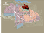
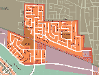
The origins of Marlborough District date back to the 1950's, around three core-centre residential sectors: one near Toupin and Henri-Bourassa boulevards; another more to the north along Toupin boulevard and a third along Cousineau and Somerset streets.
Growth continued in the 1960's and 1970's, when empty lots were filled with new two or three storey apartment buildings, multi-family dwellings and a new type of construction, specifically the townhouse, which until this time had been absent from Saint-Laurent's architectural landscape. During the 1970's the district's development became more intense, in fact 40% of its buildings were erected during this decade. In the 1980's construction took over the remaining vacant lots.