MapIndexFrançais

Interactive maps


Interactive maps

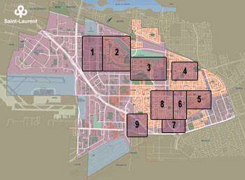
The interactive Saint-Laurent map of Saint-Laurent presents pictures of more than 48 sites of interest. Some photos are truly unique, depicting buildings that no longer exist. The map also displays photos of streets, neighbourhoods and parks, accompanied by brief historical descriptions.

Click here to learn how to use the interactive maps.

Nouveau Saint-Laurent Ouest Nouveau Saint-Laurent Bois-Franc Wartime


Vieux-Saint-Laurent Est Vieux-Saint-Laurent Centre Vieux-Saint-Laurent Sud Saint-Laurent Centre Saint-Laurent Centre Ouest


© 2001-2013 All rights reserved, Ville de Montréal
777 boulevard Marcel-Laurin, Saint-Laurent (Québec) H4M 2M7
Tel. : (514) 855-6000 Fax : (514) 855-5709